Pura GCS: Custom Ground Control Station for SUAS 2026
PURA UAV Team | Publication Date: July 2026
A Ground Control Station is the main connection between an unmanned aerial vehicle and its operator. While standard applications provide many general-purpose tools, competition missions often require a more specialized workflow.
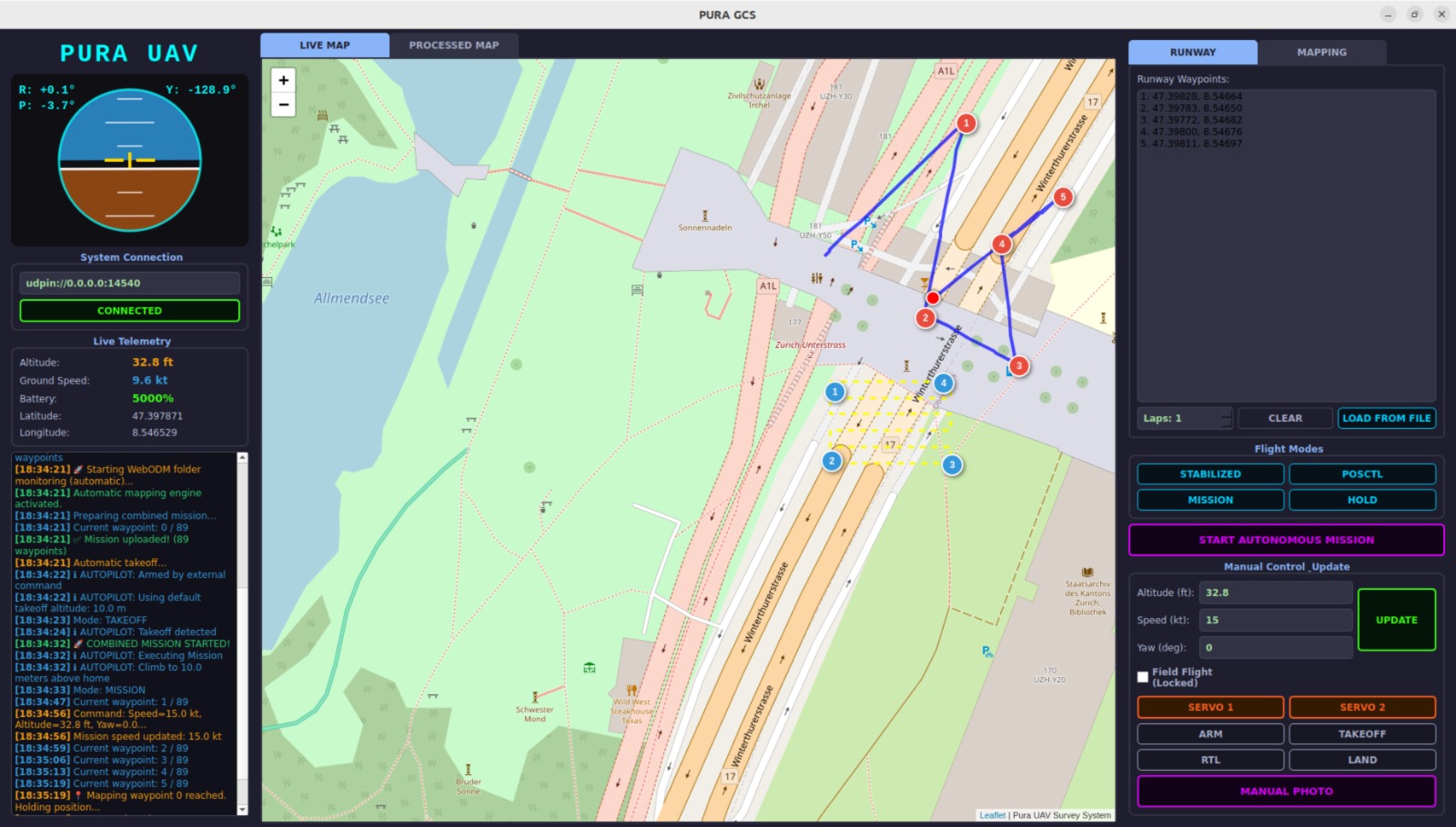
For our SUAS 2026 aircraft, we developed Pura GCS, a custom Ground Control Station designed around our own flight architecture, onboard systems, mapping workflow, and operator requirements. Rather than adapting our mission to a generic interface, we designed an interface that directly reflects the way our system operates.
Why Did We Build a Custom Ground Control Station?
During a complex autonomous mission, the operator must manage more than takeoff and landing commands. The Ground Control Station must provide unified access to:
- Real-time telemetry and flight-mode management
- Waypoint mission planning and runway-lap configuration
- Mapping-area selection and camera control
- Payload-system control and processed-map interaction
- System warnings and mission logs
Using multiple independent applications for these operations would increase workload and make it more difficult to maintain situational awareness. Pura GCS combines these functions within a single interface so that the operator can follow the entire SUAS 2026 mission without constantly switching between different software tools.
Python, PyQt5 and MAVSDK
Pura GCS is developed primarily with Python. The graphical interface is built using PyQt5, while communication with the PX4-compatible flight controller is managed through MAVSDK-Python.
MAVSDK provides high-level access to flight operations such as connecting to the aircraft, arming, taking off, landing, returning to launch, changing flight modes, uploading waypoint missions, navigating to selected coordinates, and receiving continuous telemetry. Because MAVSDK uses asynchronous operations, its communication tasks run inside a dedicated background event loop while PyQt signals transfer the received information safely to the UI.
Real-Time Telemetry and Flight Awareness
The operator can monitor relative altitude, latitude, longitude, ground speed, battery percentage, orientation angles (roll, pitch, yaw), flight mode, and PX4 status messages. Pura GCS includes a custom attitude indicator alongside a Leaflet-based live map displaying the UAV’s current position, flight path, waypoints, and target coordinates.
Mission Planning from a Single Screen
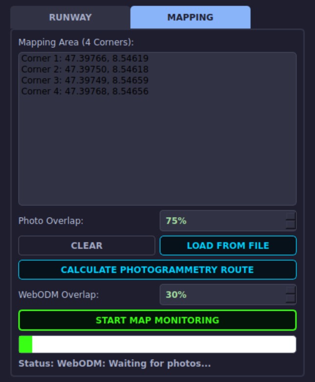
Pura GCS includes separate planning areas for runway waypoints and mapping coordinates. Runway routes can be entered manually or loaded from a file, complete with lap repetition settings. The mapping area is defined using geographic corner points, generating a survey route preview before launch. Pura GCS then combines the runway and mapping sections into a single seamless mission sequence.
Multiple Communication Channels
Not every onboard operation is handled through the flight controller. Pura GCS uses different communication methods for different subsystems:
- MAVSDK: Flight control and telemetry
- TCP Sockets: Raspberry Pi camera and payload servo commands
- HTTP: Downloading captured photographs
- WebODM API: Photogrammetric processing
Operator Control and Safety
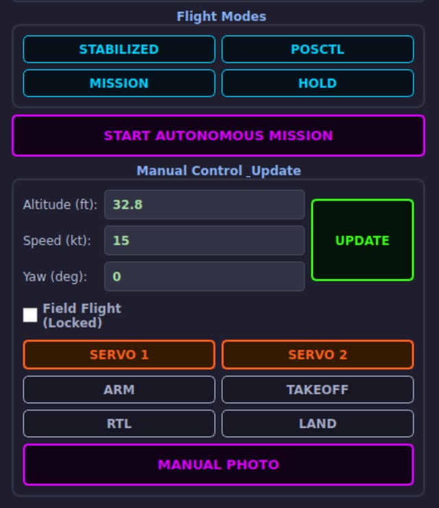
Pura GCS provides direct access to critical flight modes including HOLD, LAND, Return to Launch, Position Control, Stabilized, and Mission mode. Pressing the space bar instantly requests HOLD mode in emergencies. Before autonomous takeoff, global positioning status is verified, ensuring complete operator control during SUAS 2026 field operations.
A Central Mission Interface
Pura GCS connects the operator, PX4 flight controller, Raspberry Pi, aerial camera, payload servos, autonomous mission system, and photogrammetry mapping engine into one coordinated mission workflow tailored specifically for our SUAS 2026 goals.